Actually we planned to release v2.8 in July – anyway as we also got lots of feedback from our users and also wanted to integrated the results from a recent usability project (thx Wieland for your valuable inputs!), it took as much longer than originally planned – sorry for the delay!
Nevertheless we now decided to make a cut and release v2.8-beta1 to all users eagerly anticipating the new release :-). We kindly invite all interested users in testing v2.8-beta1 and reporting any issues by using the helpdesk, leaving a comment or using the contact form.
The highlight of the upcoming release is the support for alternative geocoding providers Mapzen Search, Algolia Places, Photon@MapsMarker, MapQuest Geocoding and Google Geocoding:
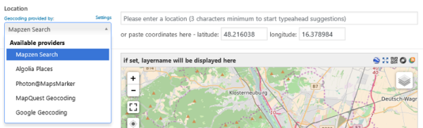
Please be aware that Mapzen Search is set as the new default geocoding provider, which even works without providing a custom API key (registering a free one is recommended though to receive higher rate limits) – Algolia Places and Photon@MapsMarker can also be used without an API key. If you want to use MapQuest Geocoding or Google Geocoding, you have to register a mandatory API key.
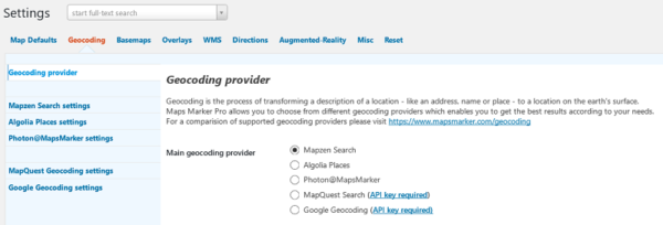
We added a new related “Geocoding” settings section – on the settings page which has been completely reorganized for better usability:
v2.8 also re-adds compatibility with MapQuest basemaps, which now require an API key.
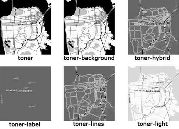
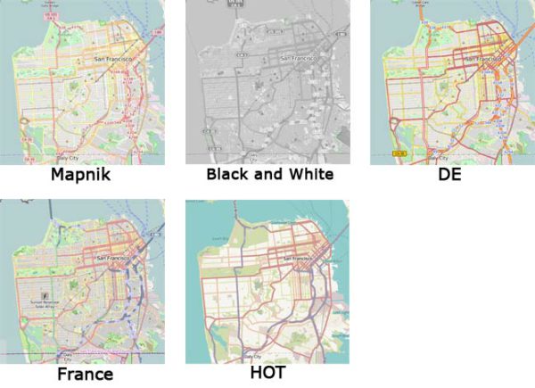
We also added support for new basemaps like Stamen Terrain and Stamen Toner, which are available in different flavors too. OpenStreetMap now also supports 5 different variants – see the updated “Basemap” settings section for more details – see below for examples.
New basemap “Stamen Terrain”:
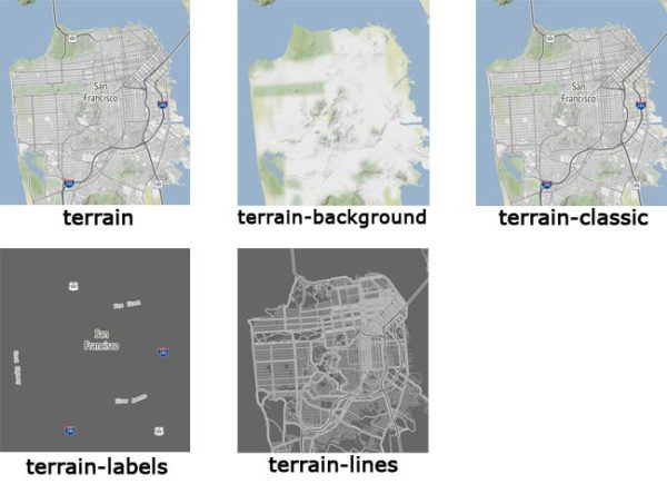
New basemap “Stamen Toner”:
New OpenStreetMap basemap variants:
Custom basemaps 1-3 and custom overlays 1-4 have also been updated with new default providers – anyway as we do not overwrite existing settings here, you need to either reset your settings to see them or delete your current inputs from the related settings sections and save the default values.
Please be aware that not all linked tutorials on mapsmarker.com (e.g. for creating API keys for search services) are available yet – we will finish them soon.
The final release v2.8 with more detailed release notes is planned to be released by the end of October, depending on issues reported by beta testers.
Please see the end of this post on how to update to v2.8-beta1.
| support for geocoding providers Mapzen Search, Algolia Places, MapQuest Geocoding, Photon@MapsMarker | |
| add support OpenStreetMap variants (Mapnik, Black&White, DE, France, HOT) | |
| add support for Stamen basemaps terrain & toner | |
| add support for MapQuest (Hybrid) basemap | |
| compatibility check for “Geo Redirect” plugin (thx Vladislav!) | |
| add .htaccess file to plugin folder to explicitly allow direct access to specific PHP plugin files (thx Nikos!) | |
| new Leaflet.markercluster option “animate” for smoothly splitting/merging cluster children (enabled by default) | |
| add info texts about marker/layer concept to better assist new users | |
| add loading indicators on license settings page to show progress of license validation | |
| new filter mmp_before_setview which allowing to utilize the map load-event (thx Jose!) | |
| support for OpenMapSurfer Bounds as default custom basemap 1 (enabled for new installs only) | |
| support for OpenTopoMap as default custom basemap 2 (enabled for new installs only) | |
| support for Hydda as default custom basemap 3 (enabled for new installs only) | |
| support for new default custom overlays Waymarked Trails and OpenWeatherMap (enabled for new installs only) | |
| add access to markers in MMP JS API (thx Jose!) | |
| increase maxNativeZoom level for OpenStreetMap from 18 to 19 for higher details | |
| option “Google Maps JavaScript API” has been reset due to compatibility reasons & disabled for new installations due to mandatory API key | |
| removed compatibility fallback from https to http for tile images & API requests if locale zh (Chinese) is used | |
| reorganized settings page for better usability | |
| jump to top of list of markers below layer maps after pagination is used (thx Mark!) | |
| improved performance of marker icons loading on marker edit & tools page (by eliminating extra http requests by using base64 image encoding instead) | |
| improved performance on backend for OpenStreetMap-based maps by support for conditional & deferred Google Maps API loading | |
| trim Mapbox custom basemap parameters to prevent broken URLs | |
| updated Leaflet.markercluster codebase to v0.5.0 (thx danzel!) | |
| updated jQuery timepicker addon from v1.6.1 to v1.6.3 (bugfix release, full changelog) | |
| updated minimap addon from v3.3.0 to v3.3.1 (bugfix release) | |
| reorder menu items and collapse links to advanced features by default for better focus (thx Wieland from http://user-experience.wien/!) | |
| hide advanced layer edit functions and make them visible on click only (to better assist new users) | |
| updated default error tile image which provides possible explanations for loading issues and also suggests solutions | |
| replaced built-in-support for OGD Vienna maps with support for basemap.at (covering whole Austria, disabled by default) | |
| updated setting link to new “Google Styled Maps Wizard” | |
| disable update button on marker edit page as long as TinyMCE HTML editor is not fully loaded to prevent issues with popuptext not saving correctly (thx JunJie!) | |
| MapQuest basemaps were broken since July 11th 2016 (automatic fallback to OpenStreetMap for existing maps if mandatory API key is not set) | |
| unresponsive map when too much markers were loaded and marker icon or marker name in list of markers was clicked (thx Daryn!) | |
| custom post types were not found for “used in content” feature, showing where a Maps Marker Pro shortcode is used (thx Brian!) | |
| markers from layer included in mlm with filter status “no” are not loaded on frontend (thx Carles!) | |
| sort order for ID in filter controlbox was by ID text and not ID number (thx Brian!) | |
| bing attribution could disappear when map getBounds() return out range values | |
| settings page could be visible to non-admins (changes could not be made though) | |
| large icons could distort “list all markers”-page (thx Hockey!) | |
| add fix for Google.asyncWait which can cause issues on mobile devices (thx nmccready!) | |
| broken initialization of click events on filters (thx Patrick!) | |
| if option “use layer zoom level for all markers” was set, popups in clusters were not opened by using links in list of markers | |
| “Too few arguments” PHP warning for list of markers sort order (thx Martin!) | |
| PHP error log entries “Undefined variable: mapname_js” if invalid shortcode was used | |
| i18n/translation issue on marker edit page (thx Hans!) | |
| custom marker icon was not used as fallback if importer errors occured | |
| errorTile-images option for custom basemap 2&3 was not considered on marker&layer edit pages | |
| action bar for list of markers was also shown on empty layer maps even if list of markers option was unchecked | |
| unsaved-warning was shown on layer edit pages even if no changes were made | |
| vertical scrolling on marker and layer edit pages was broken on mobiles | |
| map was partially broken after exiting HTML5 fullscreen view with Google Chrome (thx Maj-Britt!) | |
| “add new layer” link was not visible below layer selection list when creating new marker | |
| OpenRouteService.org directions integration was partially broken (no start point was set due to changed layer IDs – thx Marco!) | |
| autofocus on marker/layer name on backend did not work in Google Chrome | |
| compatibility check issue with W3 Total Cache Plugin v0.9.5 only (see mapsmarker.com/w3tc-hotfix for background info) | |
| Geolocation feature does not work anymore with Google Chrome 50+ unless your site is securely accessible via https (details) | |
| Translation updates In case you want to help with translations, please visit the web-based translation plattform |
|
| changed rewards for translators: get a free professional license key worth €249 for <=80% instead of <=50% completeness | |
| updated Catalan translation thanks to Efraim Bayarri, http://replicantsfactory.com, Vicent Cubells, http://vcubells.net and Marta Espinalt, http://www.martika.es | |
| updated Chinese translation thanks to John Shen, http://www.synyan.net and ck | |
| updated Dutch translation thanks to Marijke Metz – http://www.mergenmetz.nl, Patrick Ruers, http://www.stationskwartiersittard.nl, Fokko van der Leest – http://wandelenrondroden.nl and Hans Temming – http://www.wonderline.nl | |
| updated French translation thanks to Vincèn Pujol, http://www.skivr.com and Rodolphe Quiedeville, http://rodolphe.quiedeville.org, Fx Benard, http://wp-translator.com, cazal cédric, http://www.cedric-cazal.com, Fabian Hurelle, http://hurelle.fr and Thomas Guignard, http://news.timtom.ch | |
| updated German translation | |
| updated Hungarian translation thanks to István Pintér, http://www.logicit.hu and Csaba Orban, http://www.foto-dvd.hu | |
| updated Italian translation thanks to Luca Barbetti, http://twitter.com/okibone and Angelo Giammarresi – http://www.wocmultimedia.biz | |
| updated Japanese translations thanks to Shu Higash | |
| updated Latvian translation thanks to Juris Orlovs, http://lbpa.lv and Eriks Remess http://geekli.st/Eriks | |
| updated Lithuanian translation thanks to Donatas Liaudaitis – http://www.transleta.co.uk and Ovidijus – http://www.manokarkle.lt | |
| updated Russian translation thanks to Ekaterina Golubina (supported by Teplitsa of Social Technologies – http://te-st.ru) and Vyacheslav Strenadko, http://slavblog.ru | |
| updated Spanish translation thanks to David Ramírez, http://www.hiperterminal.com, Alvaro Lara, http://www.alvarolara.com, Victor Guevara, http://1sistemas.net, Ricardo Viteri, http://www.labviteri.com, Juan Valdes and Marta Espinalt, http://www.martika.es | |
| updated Swedish translation thanks to Olof Odier http://www.historiskastadsvandringar.se, Tedy Warsitha http://codeorig.in/, Dan Paulsson http://www.paulsson.eu, Elger Lindgren, http://bilddigital.se, Anton Andreasson, http://andreasson.org/ and Tony Lygnersjö – https://www.dumsnal.se/ | |
| updated Ukrainian translation thanks to Andrexj, http://all3d.com.ua, Sergey Zhitnitsky and Mykhailo, http://imgsplanet.com | |
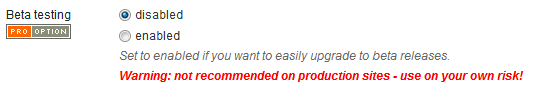
Warning: although we also test beta releases thoroughly, it is not recommended to install beta versions on production sites! In addition we recommend to backup your site (especially the database) regularly so in case of an issue with this beta release you can always perform a full rollback if needed!
In order to be able to update to this beta release, you first have to set beta-testing in settings / misc to enabled:
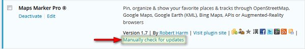
As next step after saving your settings, navigate to Plugins and click on the link “Manually check for updates” next to Maps Marker Pro:
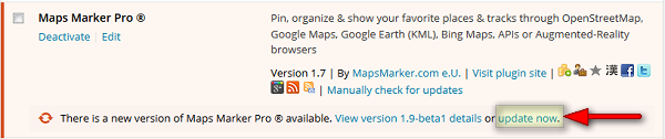
Finish by clicking on the link “Update now”.
Please use the helpdesk or contact form for bugreports, feedback or suggestions or leave a comment below – any feedback is welcome!