Actually we planned to add support for filtering on frontend with v2.6 – unfortunately due to urgent bugfixes within third-party-libraries and due to the related complexity caused by the number of changes, we decided to change our release plan and postpone filtering to v2.7. Nevertheless v2.6 has some great new features and optimizations that we are sure you will enjoy 🙂
An update to the latest version is – as always – highly recommended.
Let us know what you think about this new release by submitting a review or leaving a comment below!
If you want to keep up to date with the latest Maps Marker Pro development, please follow @MapsMarker on twitter (= most current updates), on Facebook, Google+ or subscribe to news via RSS or via RSS/email.
We would also like to invite you to join our affiliate program which offers commissions up to 50%. If you are interested in becoming a reseller, please visit https://www.mapsmarker.com/reseller
Now let´s get to the highlights of pro v2.6:
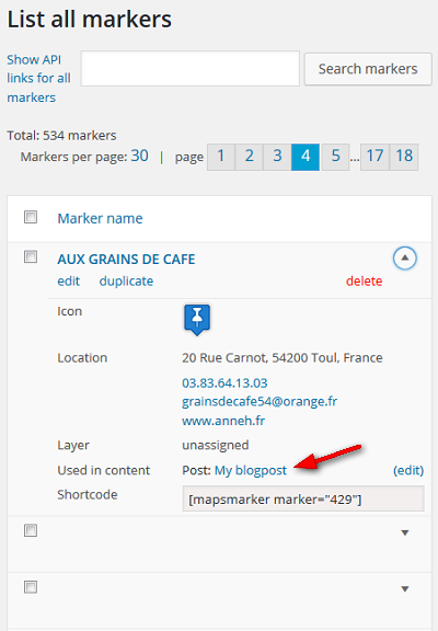
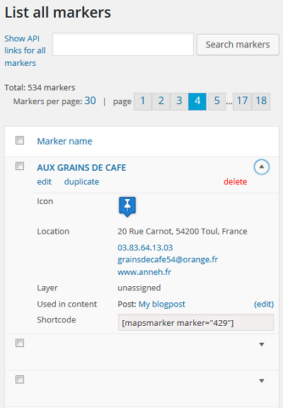
v2.6 makes it easier to manage the connections between maps and contents. On marker and layer edit pages you will see a new row “Used in content” which lists the posts, pages, custom post types or widgets where the according shortcode is used:

This info also gets displayed on the “list all markers” and “list all layer” pages within the new column “used in content” (this column can be hidden via Settings / Misc):
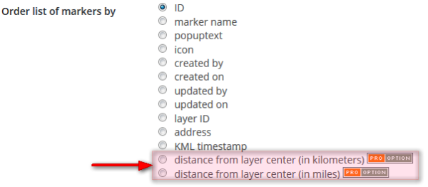
With v2.6 you can now also sort the “list of markers below layer maps” by distance from layer center. You find this new option at Settings / Map Defaults / “List of markers settings”:
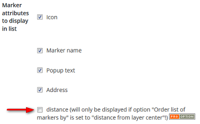
In addition, you can also choose to display the distance as marker attribute by ticking the following checkbox on the same settings page:
This will result in displaying the distance from layer center on frontend, as you can see from the following screenshot:
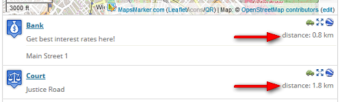
If you want to change the number of digits to show after the decimal point, please use the new option “Distance precision”, which is also available on the same settings page:

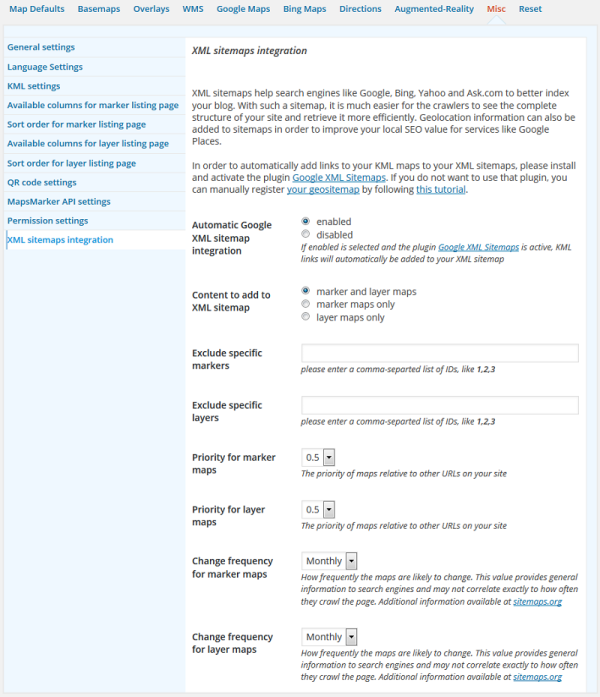
XML sitemaps help search engines like Google, Bing, Yahoo and Ask.com to better index your blog. With such a sitemap, it is much easier for the crawlers to see the complete structure of your site and retrieve it more efficiently. Geolocation information can also be added to sitemaps in order to improve your local SEO value for services like Google Places.
In order to automatically add links to your KML maps to your XML sitemaps, just install and activate the popular plugin Google XML Sitemaps (+1 million active installations) and you are done.
We also added several new options which allow you to fully customize the XML sitemaps integration according to your needs. You will find the related options within Settings / Misc / XML sitemaps integration:
A feature often requested by users has also been added with v2.6: it is now possible to highlight a specific marker on a layer map by opening its popup.
This can be achieved by either using the shortcode attribute highlightmarker followed by the marker ID to highlight (e.g. [ mapsmarker layer=”1″ highlightmarker=”2″ ]) or by adding ?highlightmarker= to the URL where the map is embedded (e.g. https://www.mapsmarker.com/?highlightmarker=1)
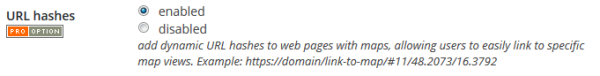
v2.6 also allows you to easily link to specific map views through the usage of URL hashes, example:
![]()
The structure of the hashes is {zoom}/{latitude}/{longitude}. URL hashes get updated if you zoom or pan the map automatically.
If multiple maps are used on one page, URL hashes get used for the first map that is loading. Please also note that URL hashes are not compatible with themes based on jQuery Mobile.
URL hashes are disabled by default for all maps – if you want to enable this feature, please change the following new option at Settings / Map defaults / Interaction options:
Before v2.6 the backend pages “list all markers” and “list all layers” did not render properly especially on mobile devices – this has now been fixed as you can see from the following screenshot:
Before v2.6 you had to use a transparent image as GPX start and end icons if you did not want to display those on your maps with gpx tracks. Thanks a lot Rich for pointing out that this has some unwanted sideeffects for marker handling.
In order to fix this, we added a new option at Settings / Map Defaults / “Default values for GPX tracks” which allows you to easily hide GPX start and end icons:
![]()
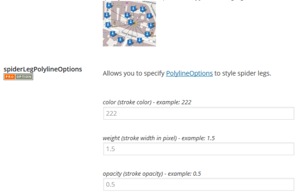
The marker clustering codebase has also been updated and now also includes new options found at Settings / Map Defaults / “Marker clustering settings” which allow you to style the “spiderLegs” of a cluster at the according zoom level:
Thanks to many motivated contributors, this release includes the following new translation:
The following translations have also received updates:
If you want to contribute to translations (new Hindi translators would be appreciated!), please visit https://translate.mapsmarker.com/projects/lmm for more information.
Please note that translators are also compensated for their contribution – for example if a translation is finished less than 50%, the translator receives a free 25 licenses pack worth €149 as a compensation for completing the translation to 100%.
Please understand that we am not being able to promise any release dates for new features. The roadmap for major new features gives you an idea where Maps Marker Pro is heading – anyway we just would want to keep the flexibility to add optimizations and bugfixes with rather unplanned minor releases resulting mostly from users feedback.
Please subscribe to this blog (via RSS or Email) or follow @MapsMarker on twitter (= most current updates) if you want to stay up to date with the latest development news.
| updated Leaflet from v0.7.5 to v0.7.7 (bugfix release – including a fix for obscure iOS issue where tiles would sometimes disappear, release notes) | |
| improved backend usability by listing all contents (posts, pages, CPTs, widgets) where each shortcode is used | |
| added option to sort list of markers below layer maps by distance from layer center | |
| XML sitemaps integration: improved local SEO value by automatically adding links to KML maps to your XML sitemaps (if plugin “Google XML Sitemaps” is active) | |
| highlight a marker on a layer map by opening its popup via shortcode attribute [ mapsmarker layer=”1″ highlightmarker=”2″ ] or by adding ?highlightmarker=2 to the URL where the map is embedded | |
| added support for URL hashes to web pages with maps, allowing users to easily link to specific map views. Example: https://domain/link-to-map/#11/48.2073/16.3792 | |
| added support for responsive tables on “list all markers” and “list all layer” pages | |
| added support for dynamic clustering preview for multi-layer-maps on backend | |
| added option to hide default GPX start and end icons (thx Rich!) | |
| added automatic check if custom plugin directory name is used (which would break layer maps) | |
| added new marker clustering options to style spiderLeg polylines | |
| added new CSS class lmm-listmarkers-popuptext-only to allow better styling of “list of markers” entries | |
| tiles for default custom basemap2 “Stamen Watercolor” are now delivered via https to prevent mixed content warnings (thx Alan & Duncan!) | |
| updated minimum recommended PHP version for built-in PHP check to 5.5 – supporting wpupdatephp.com | |
| updated leaflet locate control from v0.4.0 to v0.4.5 (bugfix release, full changelog) | |
| updated jQuery timepicker addon from v1.5.0 to v1.5.5 (bugfix release, full changelog) | |
| updated Select2 addon from v3.5.2 to v3.5.4 (bugfix release, release notes) | |
| updated minimap addon from v2.1 to v3.0 (release notes) | |
| updated plugin update checker from v2.0 to v2.2 (bugfix release, release notes) | |
| improved license key check on license settings page (check if license key starts with MapsMarker with immediate feedback) | |
| remove <br/> before address section in list of markers to enable better optional custom padding via CSS class lmm-listmarkers-hr overrides | |
| improved GPX file validity check (thx Andi!) | |
| updated markercluster codebase (using build from 27/03/2015 – thx danzel!) | |
| removed support for directions provider map.project-osrm.org as requested by project owners | |
| optimized headings hierarchy in the admin screens to better support screen readers | |
| fix MMPAPI class issue (marker assignments to multiple layers were not saved correctly) | |
| MapsMarker Web API: icon was reset to default value on updates if icon parameter was not set (thx Sohin!) | |
| incomplete map tiles display after device orientation change on mobile devices (thx Duncan!) | |
| search on settings page did not display “no matches found” if there were no search results | |
| maps in tabs or accordions created with “WPBakery Visual Composer” plugin were broken since v4.7 (thx Raitis!) | |
| directions provider openrouteservice.org changed URL schema, this resulted in broken directions links | |
| Translation updates In case you want to help with translations, please visit the web-based translation plattform |
|
| Malawy translation thanks to Mohd Zulkifli, http://www.caridestinasi.com/ | |
| updated Chinese (zh_TW) translation thanks to jamesho Ho, http://outdooraccident.org | |
| updated Czech translation thanks to Viktor Kleiner and Vlad Kuzba, http://kuzbici.eu | |
| updated French translation thanks to Vincèn Pujol, http://www.skivr.com and Rodolphe Quiedeville, http://rodolphe.quiedeville.org, Fx Benard, http://wp-translator.com, cazal cédric, http://www.cedric-cazal.com, Fabian Hurelle, http://hurelle.fr and Thomas Guignard, http://news.timtom.ch | |
| updated German translation | |
| updated Greek (el) translation thanks to Philios Sazeides – http://www.mapdow.com, Evangelos Athanasiadis – http://www.wpmania.gr and Vardis Vavoulakis – http://avakon.com | |
| updated Italian translation thanks to Luca Barbetti, http://twitter.com/okibone and Angelo Giammarresi – http://www.wocmultimedia.biz | |
| updated Latvian translation thanks to Juris Orlovs, http://lbpa.lv and Eriks Remess http://geekli.st/Eriks | |
| updated Norwegian (Bokmål) translation thanks to Inge Tang, http://drommemila.no | |
| updated Russian translation thanks to Ekaterina Golubina (supported by Teplitsa of Social Technologies – http://te-st.ru) and Vyacheslav Strenadko, http://poi-gorod.ru | |
| updated Spanish translation thanks to David Ramírez, http://www.hiperterminal.com, Alvaro Lara, http://www.alvarolara.com, Victor Guevara, http://1sistemas.net, Ricardo Viteri, http://www.labviteri.com and Juan Valdes | |
| updated Swedish translation thanks to Olof Odier http://www.historiskastadsvandringar.se, Tedy Warsitha http://codeorig.in/, Dan Paulsson http://www.paulsson.eu, Elger Lindgren, http://bilddigital.se and Anton Andreasson, http://andreasson.org/ | |
How to download / update
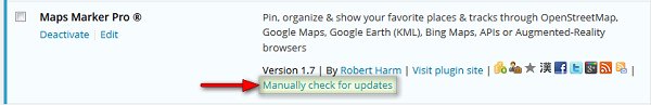
The easiest way to update is to use the WordPress update process: login with an user who has admin privileges, navigate to Dashboard / Updates, select plugins to update and press the button “Update Plugins”. The pro plugin checks every 12 hours if a new version is available. You can also manually trigger the update check by going to Plugins and clicking on the link “Manually check for updates” next to “Maps Marker Pro”:
If you do not see the link “Check for updates” and are using a version below 1.7, please update manually once by downloading the current package from https://www.mapsmarker.com/download-pro and overwritting the existing plugin files on your server via FTP. This might be needed on several hosts, which use outdated SSL libraries, which prevent Maps Marker Pro from making a secure connection to retrieve the update package from mapsmarker.com. Pro v1.7 includes a workaround for those kind of servers and the following updates should work again as usual. If you are affected and need help, please open a support ticket.
SHA-256 hash value:
46C1E0979FBFD26F2F6E45C1167D0070FF9EC14CAC1443E080E60D81B560E618
Click here for a tutorial on how to verify the integrity of the plugin package (recommended if the plugin package for a new installation was not downloaded from https://www.mapsmarker.com – verification is not needed though if the automatic update process is used)
No additional action required when updating from a beta release to this final release.