I hope you enjoy v1.8 as much as I do, as it includes new exciting features as well as great improvements “under the hood”, bugfixes and usability optimizations. Actually I added the new version to the WordPress repository yesterday – but due to license incompabilities with the fabulous Any+Time Datepicker, I had to remove it again and replace the datepicker with a GPL compatible version (= JQuery datepicker with timepicker addon). But anyway – now v1.8 is finally really available 🙂 Let´s get into detail about new features and changes:
Timestamp for more precise KML animations
From v1.0 upwards Leaflet Maps Marker has supported animations via KML in Google Earth (by using the tag <TimeStamp>). Until now, the marker creating date was used for this tag. This was enough for many usecases but didn´t allow for example to tell stories precisely via animations.
Imagine using the plugin to make a crime map which shows every incident that happend during the last month. As the date of the incident is likely to be different from the marker creation date (at least if you didnt commit the crime 😉 ) the KML animation feature within Google Earth won´t get you a precise result.
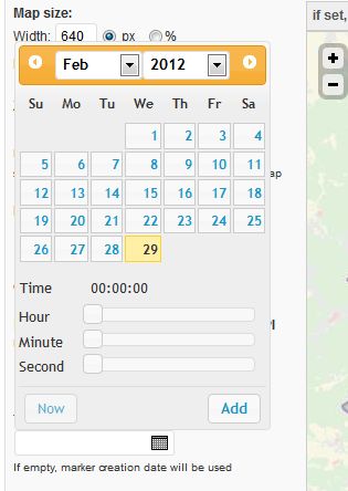
That´s why with v1.8 I added the option to add a timestamp for KML animations to each marker:

This field on marker edit page is optional – if you leave it empty, the marker creation date will be used for the <Timestamp>-tag within the corresponding KML files.
For a demo please watch the visualized bike tour through Italy, based on <a href=”http://www.lungfish.com” target=”_blank”>http://www.tripmarks.at/</a>
I am still looking for more nice showcases/Youtube videos showing this feature in action. If you build a great animation/video using this feature and would like to see it on the showcases page on mapsmarker.com, send me an email!
Reduced load for GeoJSON up to 75%
The Austrian initiative www.hermitdemzaster.at, which is trying to initiate a referendum on a more just tax system – is the first website I know of which uses my plugin to display more than 3000 markers on a single map. As the website admin contacted me to tell me that the performance gets low on several systems, I took a look into the issue and finally found a way to decrease the load for the GeoJSON feed which is needed to load layer maps by up to 75% or in absolute numbers from 3000kb down to 750kb for their GeoJSON array 🙂
This is done by reducing the parameters of the GeoJSON array internally to the absolut minimum attributes needed for displaying maps. The GeoJSON-links for maps and layers (e.g. in admin area or in the map panels) still link to the GeoJSON array with the full list of attributes in case you need this data for embedding it into other websites or apps.
This is done by the parameter &full=yes which gets added automatically to GeoJSON-Urls like https://www.mapsmarker.com/wp-content/plugins/leaflet-maps-marker/leaflet-geojson.php?layer=all&full=yes – change this parameter to no, if you want to use the light-weight GeoJSON-Array on external websites or apps.
Marker names on KML maps
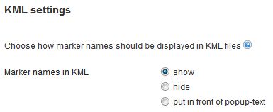
Under settings / Misc there is now a new option which allows you to configure how marker names are shown via KML in Google Earth:

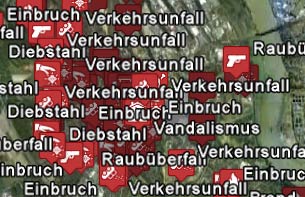
By default, the marker name is shown within the KML tag <name> which also gets displayed when opening the map in Google Earth. If you have many markers, this might be a problem as you can see from this example crime map:

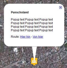
If you set this option to hide, only the icons will be shown in Google Earth. If you set this option to “put in front of popup-text”, the marker name gets added automatically to the <description>-tag and is displayed upon clicking on a marker:

You can also change this behaviour directly by adding &name=show, &name=hide or &name=popup to the corresponding KML-URLs, like https://www.mapsmarker.com/wp-content/plugins/leaflet-maps-marker/leaflet-kml.php?layer=all&name=popup
Default icon for marker maps
With v1.8 you can now also select the default icon which is used when creating new marker maps. Just enter the filename of the desired icon (e.g. smiley_happy.png) into the new option field that you find under settings / marker defaults:
![]()
If you want to use the default blue pin, just leave the field empty.
New translation: Dutch
Thanks to Marijke Metz – www.mergenmetz.nl – the plugin interface is now also available in Dutch. If you would also like to contribute a translation, please visit this page for more information.
Other changes and bugfixes
The default icon click behaviour also changed with v1.8. From now on, only markers which have a popup text (including a directions link) are clickable by the user – resulting in no more empty popups 🙂
I also fixed lots of bugs including correct calculation for KML timestamps when UTC < 0, API bugfixes and more. For a full list of changes and bugfixes, please see the full changelog below.
Full changelog:
Please let me what you think of this new release. If you have any issues, please see this page on how to get support. If an important feature is missing, please add your feature requests on Github. I am also looking for more translations – if you would like to contribute a new one, please visit this page for more information.