We are happy to announce v4.6 with support for TomTom maps and geocoding as major highlight.
Additionally we focused on code refactoring in the recent weeks, which resulted in optimized GPX support as well as general optimizations for map loading, error handling and responsiveness – for more details please see below.
An updated to the latest version is – as always – highly recommended.
![]() TomTom is a leading independent location technology specialist, shaping mobility with highly accurate maps, navigation software, real-time traffic information and services.
TomTom is a leading independent location technology specialist, shaping mobility with highly accurate maps, navigation software, real-time traffic information and services.
To achieve their vision of a safer world, free of congestion and emissions, they create innovative technologies that keep the world moving. By combining their extensive experience with leading business and technology partners, they power connected vehicles, smart mobility and, ultimately, autonomous driving.
Headquartered in Amsterdam with offices in 30 countries, TomTom’s technologies are trusted by hundreds of millions of people worldwide – and with v4.6 it is now also easily possible to use their services in Maps Marker Pro:
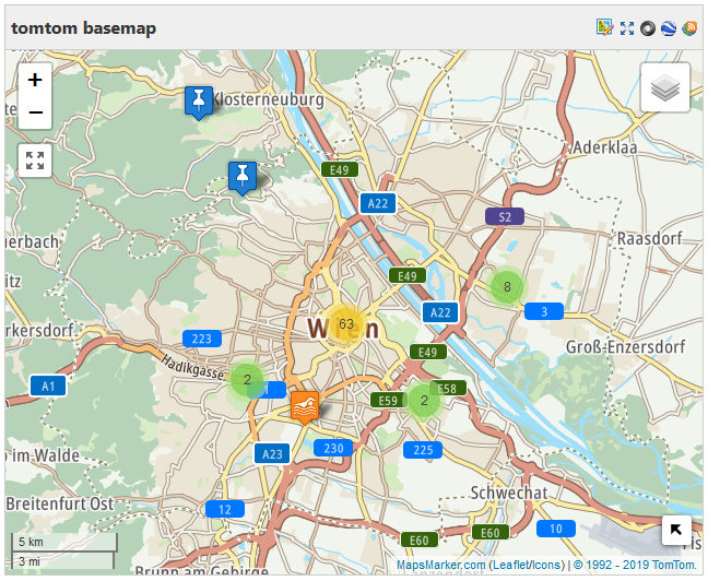
After registering a free API key, you can easily use their maps. Example default TomTom map for Vienna:
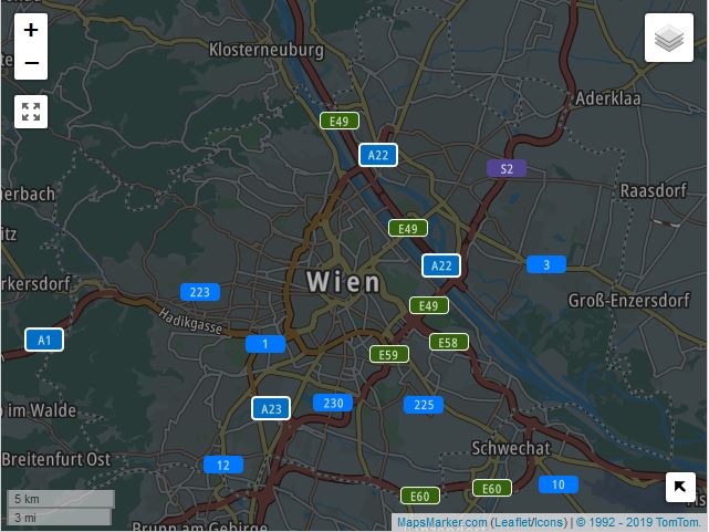
If you like dark colors, you can also use their “Night”-style-maps:
Additionally to TomTom basemap support, Maps Marker Pro v4.6 also adds support for TomTom geocoding as new provider in our geocoding framework:
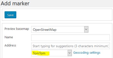
After registering a free API key, you can immediately start using TomTom geocoding on your site.
We recommend switching to TomTom as default geocoding provider, as the coverage of their geocoding data is huge and the results are very accurate.
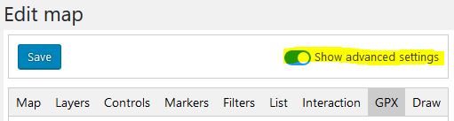
The code for the GPX parser has been optimized and we also added a few new options, which provide you with more options to customize your tracks. To see some of the new options, you need to enable the advanced editor:
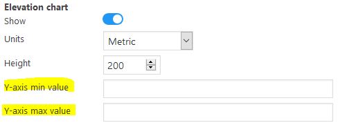
fixed Y-axis range for elevation chart
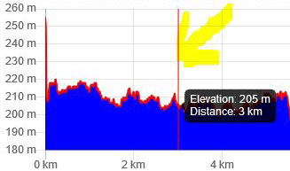
You can now set minimum and maximum Y-axis values for the elevation chart:
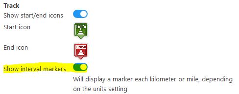
interval markers
With the new setting “interval markers” it is possible to display a marker each kilometer or mile, depending on the units setting:
Example GPX track with interval markers enabled:
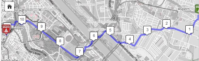
chart indicator
We also added a chart indicator for GPX elevation charts with v4.6, which can be controlled by the following new options:
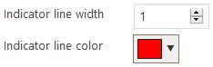
The chart indicator gets visible when you hover the GPX chart with the mouse, example:
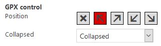
GPX control
If your GPX file comprises of multiple GPX tracks, a map control is displayed. The position and visibility of this GPX control can now be configured via tab “Controls” too:
add option to change GPX start and end icons
With v4.6 it is now also possible to change the GPX start and end icon on a map basis:
![]()
Please note that you can use any icon from The Map Icons Collection, which comprises more than 1000+ icons and is available freely at https://mapicons.mapsmarker.com/
We enhanced the “List all markers” page which now allows you to also list all unassigned markers only:

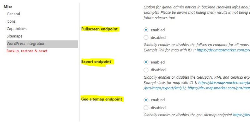
By default, all maps have a fullscreen and export endpoints, which are accessible to users by default, even e.g. if the post where the map is embedded, is password protected. In order to also support “private maps” or other similar usecases, we added new options at Settings / Misc / “WordPress integration” which allow you to globally enable or disable the fullscreen-, export- and geo sitemap endpoints:
The loading of the map has also been optimized, resulting in a more streamlined loading process and the display of a loading indicator for map tiles for example. Additionally we also added error handling for maps – showing any errors in the browser console – which helps us solving any issues more quickly.
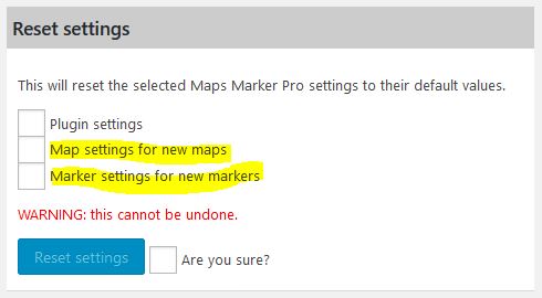
On the tools page in the section “Reset” we added 2 new options, which now allow you to also reset the values for new maps and markers to their defaults:
Changelog for version 4.6 - released on 30.08.2019 (release notes)
 | support for TomTom basemaps and geocoding | |
| optimized GPX parser and new options (fixed Y-axis range, interval markers, chart indicator, gpx control) | |
| add option to filter for unassigned markers | |
| add option to disable API endpoints | |
| add option to change GPX start and end icons | |
| add option to choose which settings should be reset to default values | |
 | optimize default values for line and fill colors for GPX elevation charts | |
| optimize map loading logic and add error handling | |
| adjust elevation chart scale when using imperial | |
| optimize and improve CSS | |
| update es6-promise to 4.2.8 | |
| show message in chart when no elevation data available | |
| optimized responsiveness: keep popup dimensions within map container | |
| span gaps on elevation chart for missing data points | |
 | fix tooltip colors not being applied properly | |
| low quality geocoding results for Google Places API | |
| fix minimap display issues when map is in a tab | |
| prevent JS error on edit marker page if no basemaps are available | |
| fix marker count on list markers page being wrong in some cases | |
| GPX not working in Edge and IE since 4.5 | |
| updated Catalan translation thanks to Roc, Efraim Bayarri, Vicent Cubells and Marta Espinalt | → contribute | |
| updated Dutch translation thanks to Ronald Smeets, Marijke Metz, Patrick Ruers, Fokko van der Leest and Hans Temming | → contribute | |
| updated German translation by Maps Marker Pro team and Daniel Luttermann | → contribute | |
| updated French translation thanks to Vincèn Pujol, Rodolphe Quiedeville, Fx Benard, Cazal Cédric, Fabian Hurelle and Thomas Guignard | → contribute | |
| updated Italian translation thanks to Luca Barbetti and Angelo Giammarresi | → contribute | |
| updated Japanese translations thanks to Shu Higash and Taisuke Shimamoto | → contribute | |
| updated Lithuanian translation thanks to Donatas Liaudaitis and Donatas Liaudaitis | → contribute | |
| updated Russian translation thanks to Ekaterina Golubina (supported by Teplitsa of Social Technologies - http://te-st.ru) and Vyacheslav Strenadko, http://slavblog.ru | → contribute | |
| updated Slovenian translation thanks to Igor Čabrian | → contribute | |
| updated Spanish translation thanks to David Ramírez, Alvaro Lara, Victor Guevara, Ricardo Viteri, Juan Valdes & Marta Espinalt and Fernando Coello | → contribute | |
| updated Swedish translation thanks to Olof Odier, Tedy Warsitha, Dan Paulsson, Elger Lindgren, Anton Andreasson and Tony Lygnersjö | → contribute | |
If you experience any issues, please search our knowledge base or submit a helpdesk ticket.
Happy mapping!

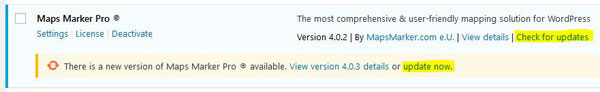
The recommended way to update is to use the WordPress update process: login with an user who has admin privileges, navigate to Dashboard / Updates, select plugins to update and press the button “Update Plugins”. The pro plugin checks every 24 hours if a new version is available. You can also manually trigger the update check by going to Plugins and clicking on the link “Check for updates” next to “Maps Marker Pro”.
If there is an update available, please start the update by clicking the link “update now”.
If you try to update from v3.1.1 or lower, please see this user guide in our knowledge base for installation instruction and a migration tutorial.
If you are using v4.6-beta1, please clear any WordPress and browser caches after updating to v4.6.
No additional actions are required for Database API users when updating to this version.
For directly downloading and installing the Maps Marker Pro as zip file, please click here.
For the SHA-256 hash value and the number of files for this release please check the following file: https://www.mapsmarker.com/SHA256SUMS.txt
This file is digitally signed with our PGP key, key signature file available at https://www.mapsmarker.com/SHA256SUMS.txt.sig
Click here for a tutorial on how to verify the integrity of the plugin package (recommended if the plugin package for a new installation was not downloaded from https://www.mapsmarker.com – verification is not needed though if the automatic update process is used).
Let us know what you think about this new release by submitting a review or leaving a comment below!
If you want to keep up to date with the latest Maps Marker Pro development, please follow @MapsMarker on twitter (= most current updates) or on Facebook, subscribe to news via RSS or via RSS/email.
We would also like to invite you to join our affiliate program which offers commissions up to 50%. If you are interested in becoming a reseller, please visit https://www.mapsmarker.com/reseller