After 8 weeks of development we are happy to announce the release of Maps Marker Pro v4.14 with some new features and many optimizations and bugfixes.
For details and highlights about this release please see below. An updated to the latest version is – as always – highly recommended.
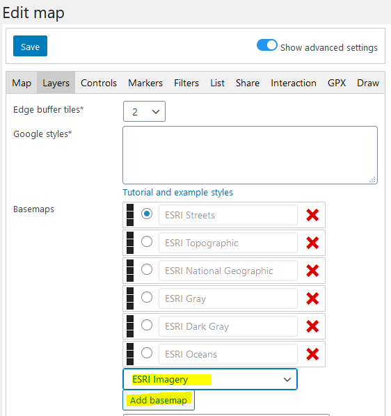
The following 7 ESRI basemaps have been added to Maps Marker Pro which can be used out of the box without prior registration:
To use those basemaps, open a map on backend, navigate to the tab “Layers” and select the desired basemap from the dropdown:
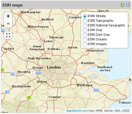
Example map:
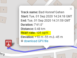
This release also supports the Garmin GPX TrackPointExtion respectively heart rate measured in beats per minutes by default.
Example map with a track which also includes heart rate values:
Map icons are saved in the upload directory at /wp-content/uploads/maps-marker-pro/icons
With v4.14 we added an icons manager to Settings / Misc / Icons so that you do not need FTP access if you want to delete icons:
![]()
With v4.14 it is also possible to add links outside the map which highlight a specific marker.
Example link: <a href="#" class="mmp-highlight" data-marker="1">Link</a>
Available options:
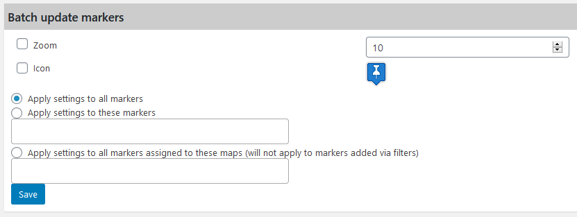
data-marker="id" The marker to be highlighteddata-map="id" Target a map with a specific ID only. Useful when multiple maps are on the same pagedata-scroll="true|false" Whether to scroll the map into view. Defaults to truedata-open="true|false" Whether to open the popup. Defaults to trueOn the Tools page you will find a new section which allows you to batch update zoom value and icon for markers:
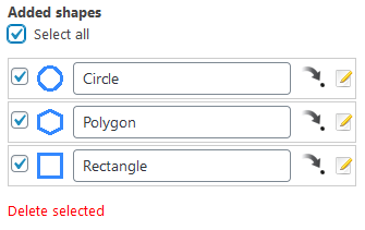
Deleting multiple shapes has also become easier with v4.14 – you can now bulk select those shapes you want to delete:
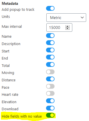
The GPX feature has also been enhanced with a new option, which allows you to hide GPX metadata fields with no value. This setting is enabled by default and is accessible if the advanced settings button is active:
The tools page has also been enhanced with 2 new sections, which allow you to delete all maps and markers at once:
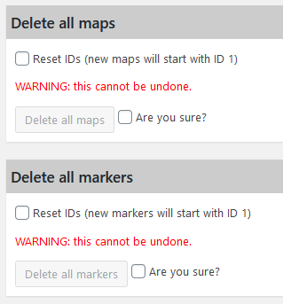
Please use with caution, as those actions cannot be undone!
We have added the following references for developers in our knowledge base:
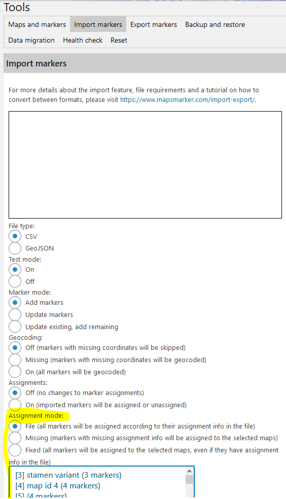
The importer has also been improved with v4.14. Now it is possible to select the assignment mode, which gives you more flexibility if the markers in the import file have no map assignements for example:
Thanks to 210+ translators this release also includes some update translations, see full changelog for details.
If you want to contribute to translations (in exchange for free licenses), please visit https://www.mapsmarker.com/glotpress/projects/mmp/ for more information.
Changelog for version 4.14 - released on 04.09.2020 (release notes)
 | add ESRI basemaps | |
| add support for Garmin TrackPointExtension in GPX files | |
| add icons manager to settings page | |
| add display support for rteType in GPX files | |
| add support for same-page highlight links | |
| add section for batch updating markers to tools page | |
| add batch delete option for added shapes | |
| add option to hide GPX metadata fields with no value | |
| add option to delete all maps / markers to tools page | |
| new in knowledge base on mapsmarker.com: filter reference | |
| new in knowledge base on mapsmarker.com: action hooks reference | |
 | improve map view on high-resolution devices (remove retina detection logic) | |
| improve assignment options for marker import | |
| disable geolocate autostart when marker highlight is used | |
| flush rewrite rules more reliably | |
| do not show icons for disabled API endpoints in maps list table | |
| new map loading animation | |
| update Leaflet to 1.7.1 | |
| update Leaflet-Geoman to 2.7.0 | |
| update Google maps mutant library v0.10.0 (fixing IE11 compatibility) | |
| update Spectrum colorpicker to v1.8.1 | |
| update qrcode-generator to v1.4.4 | |
| update PUC (plugin update checker) to 4.10 - supporting automatic plugin updates | |
| update flatpickr to 4.6.6 | |
 | fix shapes disappearing when panning or zooming the map | |
| fix marker highlight via URL parameter | |
| fix migration (regression since v4.13) | |
| prevent wrong marker scheduling values when restoring from backup | |
| fix repeatedly showing geolocation errors when list default sorting is set to distance and geolocation is disabled | |
| fix manually checking for update showing wrong result | |
| fix basemap.at bounds on edit marker page | |
| fix custom layer WMS toggle on settings page | |
| updated Catalan translation thanks to Roc, Efraim Bayarri, Vicent Cubells and Marta Espinalt | → contribute | |
| updated Chinese translation thanks to John Shen and ck | → contribute | |
| updated German translation by Maps Marker Pro team and Daniel Luttermann | → contribute | |
| updated Finnish translation thanks to Jessi Björk | → contribute | |
| updated French translation thanks to Vincèn Pujol, Rodolphe Quiedeville, Fx Benard, Cazal Cédric, Fabian Hurelle and Thomas Guignard | → contribute | |
| updated Italian translation thanks to Luca Barbetti and Angelo Giammarresi | → contribute | |
| updated Japanese translations thanks to Shu Higash and Taisuke Shimamoto | → contribute | |
| updated Russian translation thanks to Ekaterina Golubina (supported by Teplitsa of Social Technologies - http://te-st.ru) and Vyacheslav Strenadko, http://slavblog.ru | → contribute | |
| updated Spanish translation thanks to David Ramírez, Alvaro Lara, Victor Guevara, Ricardo Viteri, Juan Valdes & Marta Espinalt and Fernando Coello | → contribute | |
| updated Swedish translation thanks to Olof Odier, Tedy Warsitha, Dan Paulsson, Elger Lindgren, Anton Andreasson and Tony Lygnersjö | → contribute | |
| updated Ukrainian translation thanks to Yaroslav B Yaroshevskyy, Andrexj, Sergey Zhitnitsky and Mykhailo | → contribute | |
If you experience any issues, please search our knowledge base or submit a helpdesk ticket.
Happy mapping!

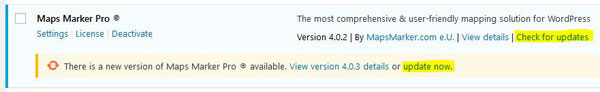
The recommended way to update is to use the WordPress update process: login with an user who has admin privileges, navigate to Dashboard / Updates, select plugins to update and press the button “Update Plugins”. The pro plugin checks every 24 hours if a new version is available. You can also manually trigger the update check by going to Plugins and clicking on the link “Check for updates” next to “Maps Marker Pro”.
If there is an update available, please start the update by clicking the link “update now”.
If you try to update from v3.1.1 or lower, please see this user guide in our knowledge base for installation instruction and a migration tutorial.
No additional changes needed (as there was no beta release for this release).
No additional actions are required for Database API users when updating to this version.
For directly downloading and installing the Maps Marker Pro as zip file, please click here.
For the SHA-256 hash value and the number of files for this release please check the following file: https://www.mapsmarker.com/SHA256SUMS.txt
This file is digitally signed with our PGP key, key signature file available at https://www.mapsmarker.com/SHA256SUMS.txt.sig
Click here for a tutorial on how to verify the integrity of the plugin package (recommended if the plugin package for a new installation was not downloaded from https://www.mapsmarker.com – verification is not needed though if the automatic update process is used).
Let us know what you think about this new release by submitting a review or leaving a comment below!
If you want to keep up to date with the latest Maps Marker Pro development, please follow @MapsMarker on twitter (= most current updates) or on Facebook, subscribe to news via RSS or via RSS/email.
We would also like to invite you to join our affiliate program which offers commissions up to 50%. If you are interested in becoming a reseller, please visit https://www.mapsmarker.com/reseller